This is the Sponsored paywall logged out

The dearth of underground asset data and inconsistencies in the way it is collected and stored has long been a problem for utilities. However, a government-backed project promises to overcome this challenge through a new data sharing register. Nadine Buddoo explores progress on the National Underground Asset Register.
To date, 35 underground asset owners have signed up to the National Underground Asset Register (NUAR). But, with approximately 650 different owners of underground assets across England, Wales and Northern Ireland, there is clearly more work to be done for the project to deliver a comprehensive data platform.
Launched in 2019 by the Geospatial Commission – which is part of the Cabinet Office – the project intends to provide a centralised database for underground asset data in England, Wales and Northern Ireland. Scotland currently has a separate platform which covers assets specifically related to the road network (see below).
As NUAR garners more engagement, the data-sharing platform aims to benefit the design and planning of infrastructure projects where data must be sourced on buried assets, such as cables, pipes and sewers. Currently, project teams are often tasked with engaging various organisations to request access to their asset information.
The sector is hugely diverse, with asset owners ranging from rural local authorities and regional utilities to national telcos and transport agencies. And, all too often, the information they provide is of varying degrees of quality and presented in different formats.
Guy Ledger, divisional digital director at Atkins and NUAR programme director, describes the complex process for acquiring data as “time consuming and inefficient”, which can lead to project delays and cost overruns. Reducing accidental utility strikes and the level of disruption and delays caused to asset owners and local communities is a significant challenge, but eliminating the potential risk to safety is also critical.
Complex challenge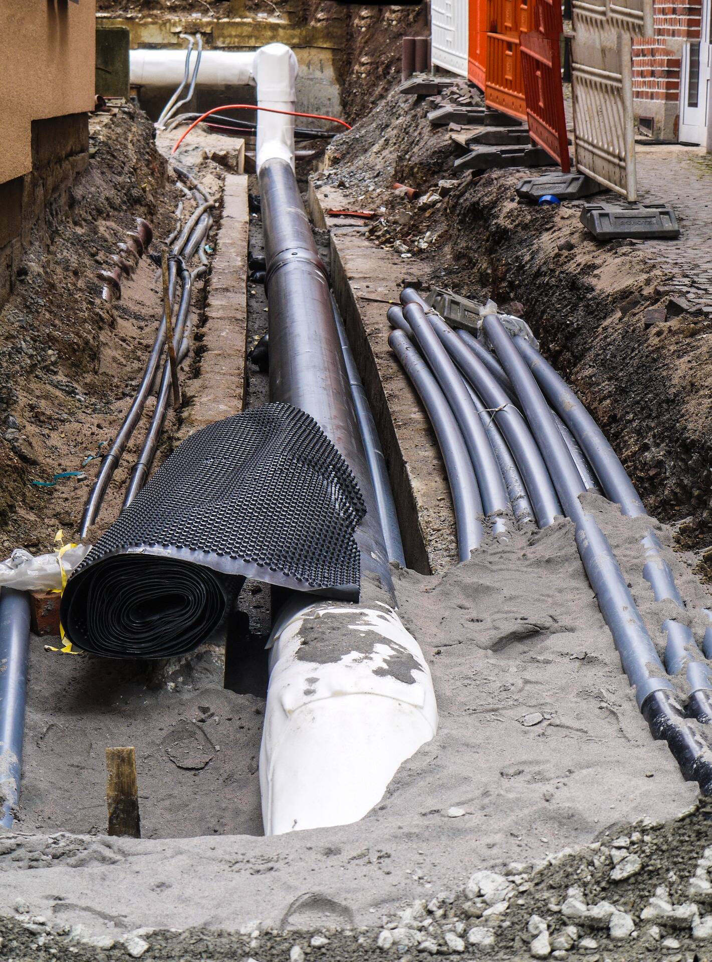
The sheer number of asset owners and the lack of uniformity across organisations in terms of the way data is collected and stored makes the current landscape particularly complex. “That complexity leads to inefficiency, but it can also lead to risk,” says Ledger.
The NUAR project aims to resolve this issue by engaging with underground asset owners to subscribe them to the register so that the location of their assets will eventually be viewable through the new platform. Access to this data will be granted solely to other registered underground asset owners and their supply chains.
Holger Kessler, NUAR stakeholder and communications lead at the Geospatial Commission, says that the overriding objective for the scheme is to create a “digital, secure, auditable, trusted and sustainable platform for sharing buried asset data”.
“We want this platform to be there forever, not just another pilot project. We want to solve this for the UK and the economy for the long term,” he adds. “We are working closely with government departments, industry, academia and the Centre for Protection for National Infrastructure to achieve this.”
In October 2021, Atkins was awarded a £23 million contract to deliver the NUAR project. The consultant’s primary role is to lead on the engagement with asset owners and the development of the new platform.
“The project is founded on data sharing agreements, so in this initial phase our work is to effectively make contact with each of the asset owners to explain what the project is and explain how they will benefit. Having hopefully convinced them of that value and benefit, we enter into a data [exploration] agreement,” explains Ledger.
“Under that agreement, we can start to understand the structure of their data now and how we will then transform it and put it into the new model.”
Beyond the initial three years of the project, a data distribution agreement will be established between the asset owner and the Geospatial Commission, which enables ongoing access to the data through the platform.
“The system will continue to ingest data – depending on the maturity of the asset owners themselves, this will be either via a direct link through to their asset data or it will be periodically refreshed data,” says Ledger.
Stakeholder engagement
The success of the register is wholly dependent on buy-in from asset owners. The more data shared, the more insight can be drawn from the system.
So, what has been the response from the utilities sector? According to Holger, the pilots proved to be successful and water companies have, so far, been most receptive. “I think that’s probably because they have to dig through everybody else’s assets to get to theirs,” he says.
Ledger adds that some asset owners have been particularly proactive by contacting the NUAR team to find out how they can get involved and become advocates. “The level of interest is high, but that’s not to say it will be the same across the board. Every asset owner is going to be a unique challenge. But we’ve had a great start.”
Bringing hundreds of organisations and their associated datasets on board is no mean feat, but the team is confident that NUAR will set a precedent for much more collaborative and community based sharing of infrastructure data.
“I’m convinced NUAR will help to crack the problem of sharing and trusting digital data,” says Holger. “Through NUAR, we’ll hopefully set a path for more sharing of other types of data. We’ll look back in five or 10 years and think ‘why wasn’t this done before?’”
What is NUAR?
The National Underground Asset Register (NUAR) project builds on initial work that started at Northumbrian Water’s Innovation Festival in 2018. The event brought together infrastructure providers, working with the Ordnance Survey, to explore how underground asset data could be collated and shared across a single platform.
Following this, the Geospatial Commission and the Cabinet Office launched the NUAR project in April 2019 with pilots in the North East of England and London to help increase the government’s understanding of how such a register could be designed and managed. This 12-month pilot phase allowed the team to test the technical feasibility of the project, as well as the appetite in the sector for increased sharing and collaboration.
While evidence from the pilot phase demonstrated high levels of participation from asset owners can be achieved without the need for further regulation, the Geospatial Commission intends to consult on the introduction of legislation to prescribe that data is shared through the platform.
The current phase of the project involves procurement of the system, which is expected to be completed in the next three years.
Lessons from ScotlandScotland is leading the charge for increased data sharing with the development of the Scottish Community Apparatus Data Vault – known as Vault. The project aims to make underground pipe and cable information accessible though the Scottish Road Works Register (SRWR), which is the country’s existing national database for the digital transfer, storage and management of road works data.
Kat Quane, road works policy manager at Transport Scotland, explains that the scheme was initially implemented by the Scottish road works community on a voluntary basis, but it is set to become compulsory.
In November 2019, Scottish Parliament passed a bill to make participation in Vault mandatory. The bill also received royal assent, but the coronavirus pandemic has delayed implementation of the new legislation.
Regardless of the imminent shift to a mandatory footing, Quane insists that Vault’s success relies on “a very collaborative community with a long history of working together”.
Unlike the NUAR project, Vault deals with above and below ground assets. But despite this difference, Quane says there is potential for cross collaboration and sharing of best practice between the two projects.
For example, the Office of the Scottish Road Works Commissioner – responsible for monitoring performance and promoting good practice across utilities and road authorities – is exploring the Model for Underground Data Definition and Integration (MUDDI) standard, which NUAR has already adopted.
There are also lessons for NUAR to take from the progress that has been made in Scotland and the collaborative approach from stakeholders.
“That’s not to say that we don’t have our disagreements and disputes, but it’s genuinely a very collaborative community,” says Quane. “Vault was something that the community themselves were really pushing for because they could see the benefit. It just makes sense to work together.”
See this content brought to life at Utility Week Live, 17-18 May 2022 NEC Birmingham
Decarbonising transport and New approaches to asset management and maintenance are among the frontline challenges at the heart of Utility Week Live 2022’s live content programme.
View the challenges and be alerted for tickets to the industry’s most eagerly awaited reunion at utilityweeklive.co.uk.
Please login or Register to leave a comment.